UN PROJET, UNE QUESTION ? APPELEZ-NOUS AU +33(0)4 65 84 71 20 - contact@instadrone.fr

Instadrone

  • NETWORK
  • SERVICES
    • Telecommunication
      • Panoramic
      • Inspection
      • Microwave Targeting
      • Pathloss Report
      • Roof modeling
      • Prospecting Assistance
    • Topography
      • Photogrammetry
      • Bathymetry
      • Multispectral
      • Lidar
    • Modelisation
      • Structures
      • BIM
      • Examples of Achievements
    • Inspection Sampling
      • Engineering structure
      • Wind Farm
      • Thermal inspection
      • Worksite monitoring
      • Underwater inspection and aquatic sampling
    • Agricultural Services
    • Instadrone’s Formation
      • Formation UgCS
      • Formation DJI Phantom 4 RTK
      • Map Pilot Formation
  • NEWS
  • CONTACT US
  • English
    • Français
    • English
    • Español
  • Home
  • NEWS
  • AR Instadrone
  • المسح الجيوفيزيائي
Monday, 22 March 2021 / Published in AR Instadrone

المسح الجيوفيزيائي

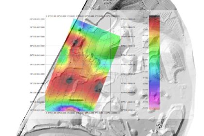
وكجزء من تعاوننا مع مكتب تصميم INFOGEO ، قمنا مؤخرا بالتقاط المغناطيسية بواسطة طائرة بدون طيار في محجر للبوزولاني بالقرب من كليرموند – فيران. وغرابة هذا المسح هي ارتفاع الطيران منذ أن حلقنا فوق المحجر بأكمله على ارتفاع 12م عقب قياس الارتفاع الفعلي للموقع. وقد أصبح ذلك ممكنا من خلال دمج نظام TAM من الموقع مؤخرا في برامجنا لتخطيط الرحلات الجوية. خطوة كبيرة أخرى اتخذت من قبل فرق Instadrone في إتقان التقاط التقنية.

  • Tweet
Tagged under: dji, instadrone, Lidar, suez, أخذ العينات المائية, أشعة الميكروويف المستهدفة, أعمال فنية, إعادة ترتيب الصور ثلاثية الأبعاد, ابتكارية, الرياح, الطائرة, المساعدة في التنقيب, النظام العالمي لتحديد المواقع, بناء نماذج للمعلومات, تدريب, تفتيش, تقرير باثفقدان, خدمات, شبكة, قياس اعماق, كاميرا Alpha 7RIV, للمسح التصويري, متعدد الأطياف, مجلس, مراقبة الموقع, مستقلة, نمذجة, نمذجة السقف, واتصات

Recent Posts

  • Instadrone integrates the ITS Fusion network of companies

    The network of companies ITS Fusion, the first ...
  • Why use a service provider for drone services?

    Drones are an industry that has grown exponenti...
  • Instadrone participation in the scientific expedition “Antartique 2.0°”

    Among the partners of the INSTADRONE expedition...
  • INSTADAYS 2021

    As every year Instadrone organizes INSTADAYS, a...
  • Acquisition of a Multinov ROView Terrestrial ROV

    We proposed to you up to the gold of the perfor...
Logo POCTEFA
  • NETWORK
  • SERVICES
    • Telecommunication
    • Topography
    • Modelisation
    • Inspection Sampling
    • Agricultural Services
    • Formation
    • Communication
  • NEWS
  • CONTACT US
  • English
    • Français
    • English
    • Español
  • LEGAL NOTICE
  • GET SOCIAL

© 2025 INSTADRONE - Tous droits réservés

TOP
We use cookies to ensure the best experience on our website. If you continue to use this site, we will assume that you are satisfied with it.