UN PROJET, UNE QUESTION ? APPELEZ-NOUS AU +33(0)6 64 94 96 32 - contact@instadrone.fr

Instadrone

  • NETWORK
  • SERVICES
    • Telecommunication
      • Panoramic
      • Inspection
      • Microwave Targeting
      • Pathloss Report
      • Roof modeling
      • Prospecting Assistance
    • Topography
      • Photogrammetry
      • Bathymetry
      • Multispectral
      • Lidar
    • Modelisation
      • Structures
      • BIM
      • Examples of Achievements
    • Inspection Sampling
      • Engineering structure
      • Wind Farm
      • Thermal inspection
      • Worksite monitoring
      • Underwater inspection and aquatic sampling
    • Agricultural Services
    • Instadrone’s Formation
      • Formation UgCS
      • Formation DJI Phantom 4 RTK
      • Map Pilot Formation
  • NEWS
  • CONTACT US
  • EnglishEnglish
    • FrançaisFrançais
    • EnglishEnglish
    • EspañolEspañol
    • PortuguêsPortuguês
    • العربية المغربيةالعربية المغربية
    • PolonaisPolonais
    • ItalienItalien
  • Home
  • NEWS
  • Instadrone-EN
  • Lidar Yellowscan Mapper
Monday, 22 March 2021 / Published in Instadrone-EN

Lidar Yellowscan Mapper

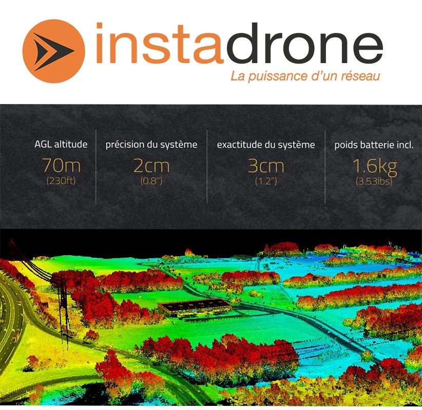
The Instadrone network, specialized in drone captures, offers its topographic surveys by airborne Lidar throughout the territory and abroad for an increased precision of your locations.

We have acquired the all-new Yellowscan Lidar to meet your needs without delay.

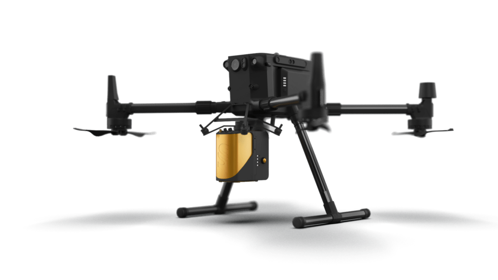
This investment was made simultaneously with the purchase of 10 DJI M300 RTK units to carry this Lidar sensor safely.

  • Tweet
Tagged under: 3D achievements, advice, ALPHA 7RIV, aquatic sampling, autonomous, bathymetry, building information modeling, dji, drone, engineering structures, formation, gps, innovation, inspection, instadrone, lidar, microwave targeting, modeling, multispectral, network, pathloss report, photogrammetry, prospecting assistance, roof modeling, S4, services, suez, wind domain, worksite monitoring

What you can read next

Instadrone’s Formation
INSTADRONE IN THE MIDI-LIBRE
Topography Phantom 4 RTK

Recent Posts

  • Instadrone integrates the ITS Fusion network of companies

    The network of companies ITS Fusion, the first ...
  • Why use a service provider for drone services?

    Drones are an industry that has grown exponenti...
  • Instadrone participation in the scientific expedition “Antartique 2.0°”

    Among the partners of the INSTADRONE expedition...
  • INSTADAYS 2021

    As every year Instadrone organizes INSTADAYS, a...
  • Acquisition of a Multinov ROView Terrestrial ROV

    We proposed to you up to the gold of the perfor...
  • NETWORK
  • SERVICES
    • Telecommunication
    • Topography
    • Modelisation
    • Inspection Sampling
    • Agricultural Services
    • Formation
    • Communication
  • NEWS
  • CONTACT US
  • EnglishEnglish
    • FrançaisFrançais
    • EnglishEnglish
    • EspañolEspañol
    • PortuguêsPortuguês
    • العربية المغربيةالعربية المغربية
    • PolonaisPolonais
    • ItalienItalien
  • LEGAL NOTICE
  • GET SOCIAL

© 2022 INSTADRONE Tous droits réservés

TOP